Forum Replies Created
-
AuthorPosts
-
After seeing pictures of you mingling with critters around the globe, then witnessing the bear ear scratch maneuver, I think you are truly a friend to all beasts. A new nickname is brewing; You know that Dr. who was a friend to all critters..
I love that underwater camera action but cannot recognize the lake. Are you sure I participated in stocking this lake? Its name would have to start with a D, C, L, J,U or S.
How’s your hand healing, Josh? 😆
There are at least a couple in Square Lake. They are welcome to eat all the overpopulated fish they can out of this lake.
Dear Josh,
Thank you for your persistence and enthusiasm in pursuing Trail Blazer membership. Please keep it up! Right now, members are hunched over maps scouting the most obscure, steep and brushy routes to lakes in hopes of inviting you. I promise it will be a very interesting hiking season this year.
It’s one thing to have your (impressive) level of skill, but to document it publicly shows a great deal of humility. You may need it after getting tagged with an unsavory nickname regarding your prowess.
Cheers,
Dave Harwell
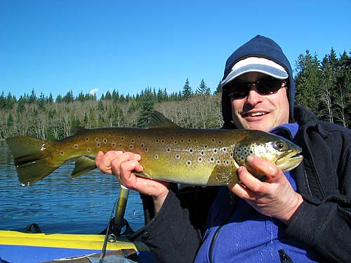
Trail Blazer PresidentI’m a little hesitant to post this because the lake is only around 1000′ in elevation. But, it’s in the woods and it is a large specimen. If folks complain I’ll be happy to yank it.
My friend Aaron used steelhead jigs all day on this lake and cleaned up. 2 very nice Browns and a handful of Cutthroat/Rainbow trout were caught in the middle of winter.
Hmmm, I may try a jig this winter….

I know a few Trailblazers frequent this fishing hole.
If I’m battling thick stuff I wear hiking pants, a long sleeve shirt or just a windbreaker for the slickness and a pair of leather gloves. Sometimes glasses for eye protection are thrown in. Depending on the trip, I may or may not wear raingear in wet brush. If it is a truly wet and difficult bash I feel it is better to just get wet than suffer in hot gear. The clothing is just to save you from “death from a thousand cuts”
Just remember to pack some dry clothes.
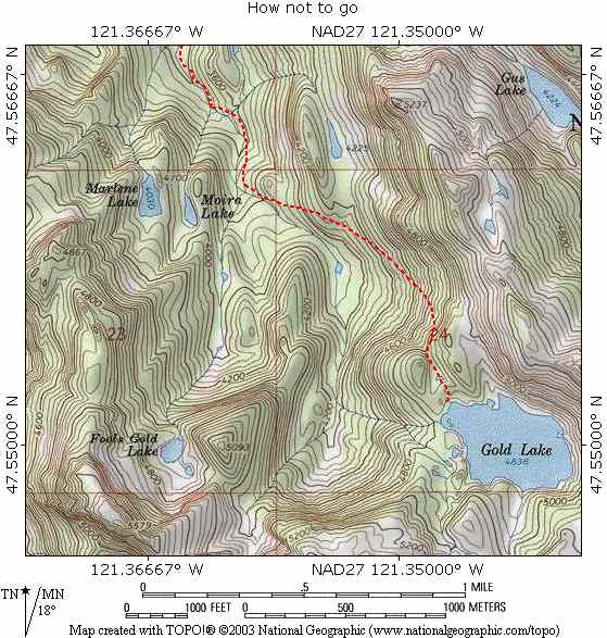
I know most of the time it is on the left (East) side. I believe it crosses in the neighborhood of the Moira confluence. Near the Gold Creek outlet it is on the left side. I am really sketchy on details from 3400′ to 3800′. A few days ago we came off the East ridge and landed near the Fools Gold confluence. We gave up looking for the trail and walked the creek for a 1/2-mile to where it became obvious on our right.
Just to show you my intelligence, I submit last years route into Gold on a rainy 4th of July weekend.

It’s a slow slog up to Gold lake. All sorts of terrain is up there. Boulders, brush, creek as trail. The tread is thin and it seems to take forever to get anywhere.
The way trail is better once you get into the upper section of the valley. I can say from experience that it is worth it to take time to find the trail. I missed a crucial part coming up and lost the trail coming down in the middle section. I still got there though. There’s lots of flags at least 1/3 of the way. We were trying to hit the Dorothy trail before dark and barely made it. Otherwise I would have pulled those flags.
I use one of these http://www.amazon.com/exec/obidos/tg/detail/-/B00004XSC3/002-6156529-6162465?v=glance It’s a standard kitchen thermometer. It works well. My only complaint is it’s easy to turn it on by accident. I just found mine with a dead battery.
-
AuthorPosts
